Study addresses safer rail transport

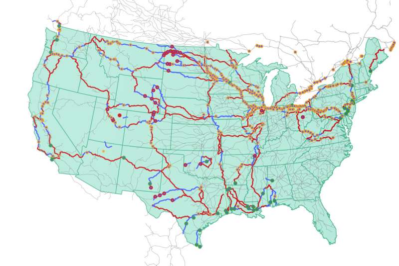
Oak Ridge National Laboratory researchers have used images from a photo-sharing website to identify crude oil train routes across the nation to provide data that could help transportation planners better understand regional impacts.
More than 300 crude oil rail incidents have occurred in the U.S. over the past decade, causing adverse consequences from fire and hazardous materials leakage. However, only limited information on the transport routes has been publicly available.
In a study published in Transportation Research Record: Journal of the Transportation Research Board, the researchers used geotagged online photos from Flickr to reconstruct transport paths. By linking geotagged crude oil train images with national railway networks, the team was able pinpoint the areas through which trains likely passed.
“Our inferred routes aligned with approximately 96% of the documented crude oil incidents and some of these routes traversed metropolitan areas,” ORNL’s Majbah Uddin said. “With this visual data, there is now a good foundation for understanding potential risks along the rail routes.”
More information:
Yuandong Liu et al, Examining Rail Transportation Route of Crude Oil in the United States Using Crowdsourced Social Media Data, Transportation Research Record: Journal of the Transportation Research Board (2023). DOI: 10.1177/03611981231170632
Citation:
Study addresses safer rail transport (2023, July 18)
retrieved 18 July 2023
from https://techxplore.com/news/2023-07-safer-rail.html
This document is subject to copyright. Apart from any fair dealing for the purpose of private study or research, no
part may be reproduced without the written permission. The content is provided for information purposes only.
For all the latest Technology News Click Here
For the latest news and updates, follow us on Google News.

